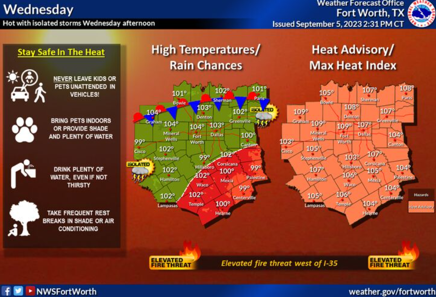
Hot conditions will persist into Wednesday with an elevated wildfire threat along and west of I-35. High temperatures will reach 100 to 105 degrees with heat index values as high as 105 to 110.
A Heat Advisory remains in effect through Wednesday evening for the entire region. Isolated storms will be possible across North Texas and western Central Texas during the late afternoon hours. Frequent lightning and strong downburst winds will be the main threats.
Wednesday
A 20 percent chance of showers and thunderstorms after 4pm. Sunny and hot, with a high near 103. Heat index values as high as 108. Southeast wind 5 to 10 mph.
Wednesday Night
A 10 percent chance of showers and thunderstorms before 7pm. Mostly clear, with a low around 82. East southeast wind around 5 mph.
Thursday
Sunny and hot, with a high near 105. Southeast wind 5 to 10 mph becoming west southwest in the morning.
Thursday Night
Clear, with a low around 83. East southeast wind 5 to 10 mph becoming south after midnight.
Friday
Sunny and hot, with a high near 106. South southwest wind 5 to 10 mph.
Friday Night
A 20 percent chance of showers and thunderstorms. Partly cloudy, with a low around 79. South southeast wind 10 to 15 mph, with gusts as high as 25 mph.
Saturday
A 30 percent chance of showers and thunderstorms, mainly after 1pm. Sunny and hot, with a high near 99. East southeast wind 10 to 15 mph, with gusts as high as 20 mph.
Saturday Night
Mostly clear, with a low around 76. East southeast wind 10 to 15 mph, with gusts as high as 20 mph.
Sunday
A 20 percent chance of showers and thunderstorms. Sunny, with a high near 96.
Sunday Night
Partly cloudy, with a low around 74.